
MESA DE CUBA BADLANDS
BY MICHAEL RICHIE
FROM: “ Mesa De Cuba Badlands—Makin’ Tracks,” New Mexico Magazine, March 2003, with 2 color photos.
AND: “Mesa De Cuba Badlands,” Inside/Outside Southwest Magazine published by the Durango Herald, November/ December 2007, with 5 color photos.
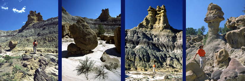
Walking slowly along the base of Mesa De Cuba, we pause frequently to admire the myriad shapes, colors and textures surrounding us. I’m reminded of a mysterious, far off city with a winding lane that passes countless bazaars and side passages filled with exotic art treasures, larger-than-life statues, and lavishly decorated buildings. The topography of the Mesa De Cuba badlands is different from any I’ve explored. Rather than being spread over a large area, they stretch for long distances all along the amazingly convoluted mesa base. If you followed every curve and indentation you’d be walking 3-4 actual miles for each linear mile traveled--and every inch is packed with formations.
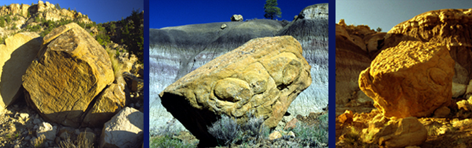
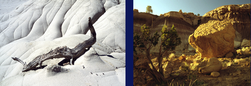
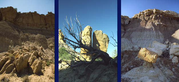
Strangely contoured hoodoos grow from knife-edged ridges. Rock turrets soar skyward, some split by vertical crevices wide enough to climb through. Perfectly round, maroon colored stone spheres lie scattered by the hundreds like neglected marbles. They range in size from inches to a yard wide. Technically known as “iron concretions”, these odd rocks add a whimsical quality to the walk. Petrified wood is strewn everywhere in various sized pieces and full-fledged logs. In places huge, richly striated, intricately pitted boulders have rolled down from the mesa sides to form labyrinths guarding overhanging amphitheaters.
Each new concavity or steep arroyo carved into the mesa walls holds a new rock sculpture or weird erosion feature, but the overall color scheme remains similar. Yellows, reds, purples and an intense, fluorescent tangerine that I’ve never seen anywhere else in such abundance accent whites, grays, and charcoals.
Cross-country hiking through this combination obstacle course and amusement park is as relaxing or strenuous as you choose to make it. The easiest route hugs the mesa base where the surprisingly even terrain is regularly interrupted only by mostly gentle arroyo channels. If you decide to enter an arroyo the going can get tougher requiring picking your way through boulder piles and up overhanging ledges as the passage gets increasingly narrow. The next difficulty level involves scaling the ubiquitous little ridges and channels to get views from better vantage points or check out a particularly interesting formation. Such unfettered scrambling and gully hopping is guaranteed to bring out the kid in anyone.
The Mesa De Cuba badlands take their name from an oblong, upraised chunk of sedimentary rock that stretches for 7 miles south from the continental divide along highway 550 due west of Cuba. Thickly forested with huge old ponderosa, the 7600 feet elevation top is part of Santa Fe National Forest. The BLM administers the land at the southern end and along the western base where the most accessible badland formations lie.
The colorfully sculpted, 800 feet high Mesa De Cuba walls are composed of just two sedimentary layers formed in sequence starting about 63 million years ago. Made of sand and mud sediments carried by rivers from the then rapidly rising and eroding San Juan Mountains just to the north, they span the early mammal expansion into the cornucopia of environmental niches left empty by the dinosaur’s sudden demise.
Exceptionally rich in fossils, the younger, orange, sandstone top was deposited during Eocene times about 55 million years ago. The mammal revolution was gaining momentum but giant flightless birds were still the top predators. Known as the San Jose formation, the fine-grained sandstone ranks among the best in the country for early mammal fossils including a fox sized animal that was the first step in the long evolutionary development of the horse.
Equally rich in early mammal fossils, the thicker multi-colored base, known as the Nacimiento formation, was deposited during Paleocene times just after the dinosaur’s sudden disappearance. Together with the underlying Cretaceous sedimentary rock, these layers make the San Juan Basin one of only a half dozen places on the planet where paleontologists can study a continuous terrestrial fossil record spanning the puzzling transition from dinosaurs to mammals.
The strangely organic appearing raw earth forms surrounding us provide the perfect backdrop for our musings about life’s twists and turns over the eons. But after thoroughly enjoying the easy walking past constantly changing formations we decide to try something more challenging and try reaching the mesa top via a likely looking arroyo.
Scrambling over boulder slides and pockets of crumbling soil, we slowly ascend the v-shaped chasm incised into the rainbow-striped, rock walls. Dark gray seams of low-grade coal hint at the lush, swampy environments that once existed here. At times we find ourselves climbing through petrified logjams. What seemed a steep arroyo is actually a series of hanging balconies and hidden sculpture galleries featuring mini-hoodoos and multi-hued chunks of petrified wood resting atop eroded soil pedestals. Some chambers even have side channels leading to still more exhibitions.
After finally getting stopped by a 50-foot high cliff at the top, we soak in the aerial perspective and marvel at the complexity of just this one little, formation filled arroyo. There are countless more carved into the mesa, most larger and more branching, assuring that you’ll probably never run out of amusing places to explore in the beguiling labyrinth that is the Mesa De Cuba Badlands.
| HOME |
GEOLOGY |
PHOTOGRAPHY TIPS | RECREATION | MAP - INDIVIDUAL BADLANDS |
| INDIVIDUAL BADLANDS PAGE | PHOTO TOURS |
BADLANDS OVERVIEW |
This site is property of PhotoTrekNM. All rights reserved. Copyright 2007.