
THE SAN JUAN BASIN BADLANDS BY MICHAEL RICHIE
FROM: “7 San Juan Basin Badlands,” InsideOutside Southwest Magazine published by the The Durango Herald, June/July 2005, with 7 color photos. AND: “The Good, the Bad, the and the Beautiful – New Mexico’s 9 Best Badlands,” New Mexico Magazine , Jan 2007, cover story with 6 color photos. New Mexico ’s San Juan Basin badlands are the ultimate expression of the high desert’s mysterious, dual personality. They showcase simultaneously it’s hard, desolate heart and beguiling beauty. Intricate, weirdly evocative formations create giant avant garde sculpture gardens; while wide open spaces, obstacle course mazes, and hand-over-hand slot canyon ascents offer exciting, cross-country hiking. World renown, the Bisti Wilderness is just one of nine otherwise virtually unknown badlands waiting to be explored in New Mexico’s San Juan Basin. See the location map.
What exactly is a badland? — The shortest answer: a place where “hoodoos” grow in profusion. These oddly shaped cap rocks sitting atop slim pedestals lend a phantasmagorical feel to the landscapes. They come in every imaginable form and diverse colors. Whether as solitary, Zen-like sentinels or teaming, baroque armies, they produce other worldly scenes reminiscent of a Daliesque dreamscape--or maybe a Dr. Seuss book. Hoodoos epitomize the desert’s paradoxical character with twisted humor. Carved from stone and soil by the forces of wind, rain, heat, and frost, they appear strangely organic. It’s the same raw earth sensuality often portrayed by Georgia O’Keefe. There are several ironic overtones here where purely inorganic forces and materials produce such life like forms. The now desolate country side with it’s countless, weirdly organic rock forms, somehow mirrors lush biological communities that thrived millions of years before when the area was networked by rivers and wetlands along ancient seashores.
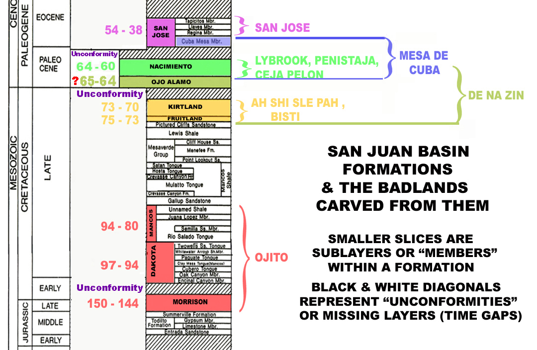
Tucked into New Mexico’s northwest quadrant, the San Juan Basin is the hoodoo capital of the world. Roughly circular with a 100 mile diameter, it stretches from just above the Colorado border south to beyond I-40 and from the Rio Grande Rift Valley’s edge, west to the Arizona border. This gentle depression has been collecting sediments for about 200 million years since the middle dinosaur age. A few time gaps, where uplift and erosion prevailed, interrupt the resulting 2 mile thick sedimentary layer cake, but a nearly continuous record of ancient environments is preserved in the stacked layers, or “formations”, up until about 38 million years ago. See stratigraphy diagram . For most of its time the San Juan Basin held exceedingly rich and diverse ecosystems. Slowly advancing, then receding inland seas and shorelines, estuaries, huge forested river deltas, meandering streams, bogs, and numerous freshwater lakes all left dinosaur and very plentiful early mammal fossils, along with massive, widespread petrified wood caches. Periodic volcanic ash showers from the rapidly rising San Juan Mountains just to the north greatly enriched the ever thickening deposits that would later become the perfect medium for nature’s sculpting prowess. The ash, with its diverse hues from iron and manganese minerals and extra, crystal forming silicates, is responsible for the truly impressive petrified tree trunks which make Ceja Pelon, the Bisti, and several other neighboring badlands paleontological treasure troves. See the fossils and petrified wood page. The basin didn’t take its saucer-like shape until 20 million years ago when widespread faulting, volcanism, and uplift along the boundary exposed older, underlying layer edges to the elements and accelerated erosion. One look at a color coded, regional geologic map presents a clear picture. Warped upward along their perimeters, the exposed, relatively thin layer edges form huge concentric circles with the oldest, bottom layers at the basin’s outer edge and the youngest, topmost layers in the center. Recently designated Ojito Wilderness for example is carved from the oldest 150 million year old Morrison layer exposed along the basin’s southern edge while the San Jose Badlands lie in the youngest 40 million year old, San Jose layer nearer the center.
The Geology Overview section of this website presents extensive, in depth information on the San Juan Basin’s long, varied geologic history and the planetary processes that create the badlands. Each San Juan Basin badland covered in this overview has a unique character but they also have several things in common. All lie on public lands, but most are difficult to find and involve varying amounts of driving on rough, unsigned, dirt roads. None have any marked trails or surface water. And except for the Bisti and Ojito Wildernesses, little or no recreational information exists. All visitors should respect the badlands’ surreal beauty and their vulnerability. Smaller hoodoos are easily damaged and petrified wood should be left for future hikers. Remember that it’s illegal and unethical to carry off vertebrate fossils or Indian artifacts. See the recreational information page.
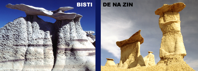
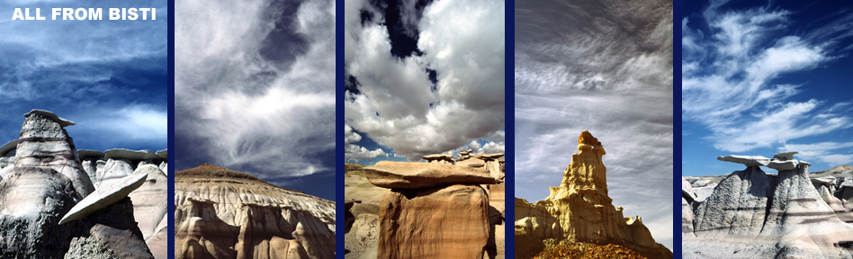
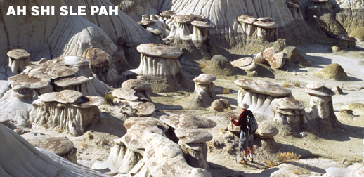
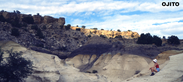
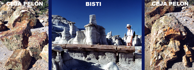
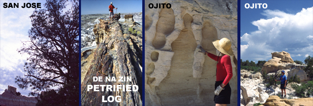
At the basin’s southeastern edge, the Ojito Wilderness’ countless natural sculptures and sweeping vistas are only part of the reason why it is New Mexico’s newest official wilderness area. Bonsai ponderosa and ancient, character laden junipers clinging to bare rock give xeriscaping new meaning. Petrified wood litters the hoodoo galleries. Ojito’s lowest, and the San Juan Basin’s oldest layer, the widespread, 150 million year old Morrison formation in other southwestern states had produced the most exceptional Jurassic dinosaur fossils in the world. New Mexico seemed left out of the picture until 1985, when Ojito divulged 8 vertebrae and several leg bone fragments from the 120 feet long, 100 ton Seismosaurous which at the time was the largest dinosaur species yet discovered. Ojito’s upper two layers, the Dakota Sandstone and later Mancos Shale formations, chronicle an ancient ocean as it slowly expanded and flooded the basin. Deep water marine fossils characterize the 85 million year old Mancos layer. Fast forward 3 layers in toward the basin center to the 75 million year old Fruitland/Kirtland formation from the late Cretaceous. The area was a vast swampy river delta along retreating seashore. The last dinosaurs roamed where fresh and salt water lagoons mingled beneath giant cypress forests. Nowadays the 30,000 acre Bisti Badlands Wilderness offers one of the most entertaining hiking experiences on the planet. A branching dry wash network provides entry to a gargantuan sculpture labyrinth beyond description. Never ending hoodoos in diverse color combinations overwhelm the senses. Throw in the 50 feet long petrified logs and you’ve got desert rat nirvana. Not far to the southeast, also in the Fruitland/Kirtland formation, the Ah Shi Sle Pah Badlands at first sight resemble the Bisti but subtle differences in topography and color schemes soon become apparent. Beautifully banded patterns rendered in alternating grey, black, white, tan, pale orange, yellow, light purple, and olive shades grace the many delicate hoodoo spires. The area is rich in dinosaur fossils and petrified upright tree stumps.
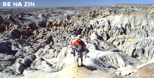
Paleontologists are particularly interested in the neighboring De Na Zin Wilderness. It’s one of a dozen places on earth where, they can study a terrestrial sedimentary record spanning the 65 million year old Cretaceous-Tertiary boundary marking the demise of a 150 million year long dinosaur dynasty and the beginning of mammalian rule. Although partially carved from the Fruitland/Kirtland formation, the upper De Na Zin areas have much different styled hoo doos than the Bisti or Ah Shi Sle Pah. The upper reaches lie in the Tertiary’s Ojo Alamo and Nacimiento formations. Numerous sandstone arches jut above huge petrified logs. Massive, dramatically carved, deep red cap rocks add a distinctive personality to the many thick-walled, highly crenellated hoodoos. Move forward in time and one layer closer to the center, where the 65 million year old Nacimiento formation is the most prolific and diverse badland producer in the basin. This complex mix of sandstones, siltstones and shales began forming in the Paleocene period of the Tertiary as early mammals were just gaining an evolutionary foothold in the basin’s lush forested flood planes. A classic Nacimiento badland, sprawling Penistaja Mesa has an extremely complex perimeter surrounded by dozens of equally complicated smaller mesas and buttes. The end result is a formation filled canyon labyrinth and miles of mesa edges carved into fantastically shaped cliffs hiding numerous hoodoo galleries. Isolated mesa tops shelter superbly xeriscaped botanical parks showcasing the incredible strength and beauty of New Mexico’s high desert vegetation. Huge petrified tree trunks decorate the canyon bottoms. Ceja Pelon Mesa lies just a few miles west from Penistaja also in the Nacimiento layer. The mesa edge above the badlands sports ample hoodoos and sensuously contoured sandstone curves but has a more linear layout. Ceja Pelon hides the largest, most colorful concentration of giant petrified logs anywhere in New Mexico. One bowl in particular literally holds petrified log jams where dozens of 50 feet long broken trunks, still lying in place, are strewn about, some piled across each other at various angles. Five feet diameter stumps rest in upright position near large, brilliantly patterned pieces of trunk sitting on eroded pedestals.
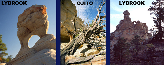
The Lybrook Badlands are the largest of the Nacimiento badlands dropping over 700 feet in 3 distinct, multi-colored, intricately eroded stair steps. Extensive vertical relief and towering buttes lend grandeur reminiscent of Bryce Canyon. These little known but highly accessible badlands rival the Bisti in size and surpass it in the diversity of both hoodoos and vegetation. Ancient Juniper roots claw at naked cliff edges anchoring huge sinuous trunks which flow and curve like the finely drawn sandstone layers from which they grow. Forests of twisting, branching bonsai ponderosa clutch at jagged mesa walls. The endless Lybrook hoodoos feature precariously balanced, brilliant red cap rocks so intricate, ingenious, and down right artistic that it’s difficult to believe they’ve been created by the random interactions of natural forces instead of in a Santa Fe sculpture studio. The Mesa De Cuba badlands stretch for 10 miles along an amazingly convoluted mesa whose bottom half is formed from the Nacimiento formation and top from the slightly younger San Jose formation. Many deeply penetrating, branching dry washes turn the hike into a visit to an exotic city with winding lanes that pass countless bazaars and side alleyways filled with larger-than-life statues and lavishly decorated buildings. Walking into and out of every wash would involve 4-5 actual miles for each linear mile traveled. Petrified wood is strewn everywhere in various sized pieces and full-fledged logs. Huge, perfectly round stones called iron concretions, some up to 5 feet across, lie scattered like forgotten marbles.
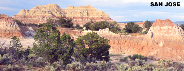
The youngest and topmost San Jose formation forms a disk at the basin center instead of a ring. This San Jose formation was deposited beginning about 54 million years ago during Eocene times when mammal evolution was really gaining momentum. The San Jose badlands are composed mainly of softer shales and siltstones. Hoodoos are less numerous, but larger with very unique cap rocks. Lavish textures, intricate erosion patterns, and rainbow colors provide plenty of visual excitement. Mammal fossils are common and Anasazi pottery shards are scattered along the forested ridgeline. The road in follows an east-west tending line of formations to the continental divide where the main north-south escarpment is carved into purple-banded castle turrets and elegant towers. Occasional petrified logs stick out of cliff faces. Finding and exploring these hidden San Juan Basin Basin hoodoo galleries requires some planning and caution. Their remoteness, temperature extremes, lack of water, confusing terrain, potential for flash flooding and sudden transformation into muddy quagmires add elements of danger. But don’t let this stop you from discovering a quintessential New Mexican experience which will bring out the desert rat – and kid—in everyone. See the hiking and recreation page for more details.
|
| HOME |
GEOLOGY |
PHOTOGRAPHY TIPS | RECREATION | MAP - INDIVIDUAL BADLANDS |
| INDIVIDUAL BADLANDS PAGE | PHOTO TOURS |
BADLANDS OVERVIEW |
This site is property of PhotoTrekNM. All rights reserved. Copyright 2007.