
THE SAN JUAN BASIN:
HOO DOO CAPITAL OF THE WORLD

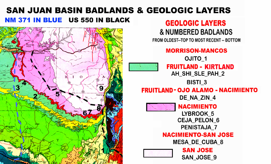
SAN JUAN BASIN GEOLOGY
The San Juan Basin is a huge, roughly circular sedimentary layer cake located in the northwest corner of New Mexico. About a hundred miles across, it stretches from the Rio Grande Rift Valley east to the Arizona border: and from the Colorado border south to the Gila Volcanic Plateau below I-25. Eighteen rock layers or formations are stacked on top of each other in the San Juan Basin. A "formation" refers to a widely recognizable layer deposited during a specific geologic time span.
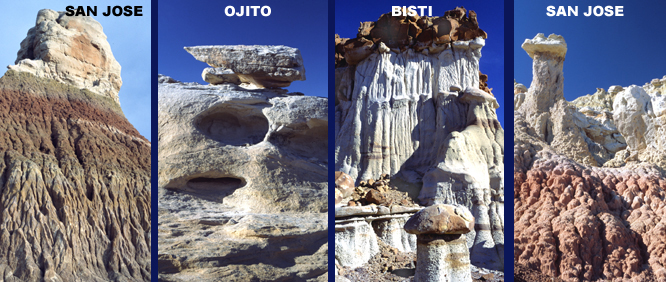
The oldest, bottom San Juan Basin layer, which geologists call the Chinle formation, was deposited beginning about 230 million years ago and ending 213 million years ago during the Triassic age when dinosaur evolution was first taking off. The youngest, topmost layer called the San Jose formation was deposited during a 54 to 38 million year ago time span when early mammal evolution was gaining speed. See stratigraphy diagram 1 for more details.
The combined 18 layers are currently about two miles thick. Original sediment deposits were probably twice that thick before compression over many millions of years turned them into rock. Flattened petrified logs found scattered all across the basin attest to the forces involved.
THE SAN JAUN BASIN STRATIGRAPHY DIAGRAM
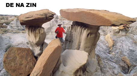
Geologists show formation names and order using “stratigraphy diagrams.” To view San Juan Basin formations and the badlands they form see stratigraphy diagram 2. Text colors are the same ones used in the badlands location map and represent formations from which the badlands are carved. Depositional time spans, measured in millions of years before the present, for various formations are also shown in the same colors. Several formations are divided into groups of smaller named sub layers called members. More will be said about formations and members later.
Note areas of diagonal lines between some formations.They represent missing time spans, called unconformities, in succession of layers. Actual layers on either side of an unconformity are physically contiguous, they rest on each other, but there is a time gap between them when erosion instead of deposition was occurring. Unconformities obviously make geologic history reconstruction more difficult. Bothersome San Juan Basin unconformities lie between the Morrison and Dakota formations, the Kirtland and Ojo Alamo formations, and the Nacimiento and San Jose formations.
The older, lower Chinle, Morrison, Dakota, and Mancos formations are found widespread around the American west, but remaining layers up to the topmost, youngest San Jose, occur only in the San Juan Basin.
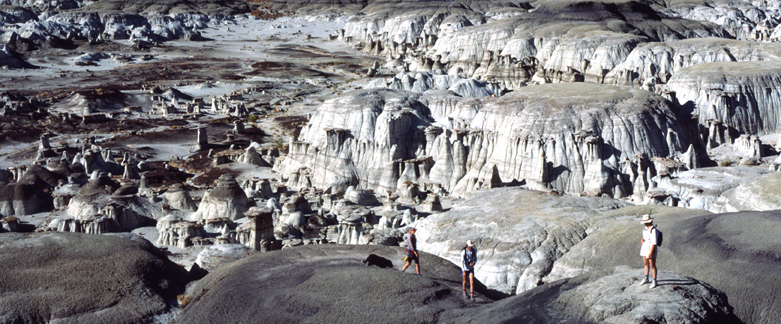
PLATE TECTONICS & THE SAN JUAN BASIN
The basin has been subjected to ongoing tectonic deformations beginning about 55 million years ago when the lengthy, widespread Laramide mountain building episode reached the southwest. This massive tectonic uplift pushed the basin sediments thousands of feet in the air. Layers that were formed below sea level are now 7000-8000 feet above it. The continental divide crosses the basin at about 7400 feet and some higher badland mesa tops reach over 8000 feet.
The basin didn’t take its giant saucer shape until 20 million years ago when widespread faulting, volcanism, and uplift along the boundary exposed older, underlying layer edges to elements and accelerated erosion. One look at a color coded, regional geologic map presents a clear picture. Warped upward along their perimeters, the exposed, relatively thin layer edges form huge concentric circles with the oldest, bottom layers at the basin’s outer edge and the youngest, topmost layers in the center. The recently designated Ojito Wilderness for example is carved from the older, lower, 150 million year old Morrison layer exposed along the basin’s southern edge while the San Jose Badlands lie in the youngest 54 million year old, San Jose layer nearer the center.
PALEOECOLOGY: STUDYING ANCIENT ECOSYSTEMS
Exposed, chronologically ordered sedimentary layers are uniquely suited to conveying information about the far distant past. Different rock types, their fine structure, chemical profiles, and fossils all provide information that geologist and paleontologists use to reconstruct detailed pictures of environments and biological communities that existed 100’s of millions of years ago. Paleoecology, as the study of past earth ecosystems is called, employs diverse scientific data and clues in an analogous manner to CSI work.
Each of the 18 San Juan Basin layers or formations represents one chapter in a regional biography that spans over 200 million years. Several unconformities result in a few missing chapters, but the rock and fossil record shows that for most of its time the San Juan Basin held exceedingly rich and diverse ecosystems. Slowly advancing, then receding inland seas and shorelines, estuaries, huge forested river deltas, meandering streams, bogs, and numerous freshwater lakes all left dinosaur and very plentiful early mammal fossils, along with massive, widespread petrified wood caches.
Now desolate countryside, with its countless organic appearing hoo doos, hints at lush biological communities that thrived millions of years before when the area was networked by rivers and wetlands along ancient seashores.

| HOME |
GEOLOGY |
PHOTOGRAPHY TIPS | RECREATION | MAP - INDIVIDUAL BADLANDS |
| INDIVIDUAL BADLANDS PAGE | PHOTO TOURS |
BADLANDS OVERVIEW |
This site is property of PhotoTrekNM. All rights reserved. Copyright 2007.